The Rules That Broke India's Cities
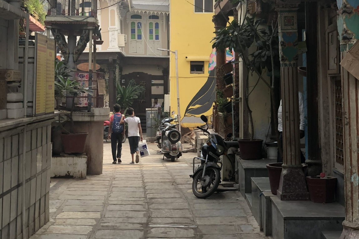
India recently crossed the $4 trillion economy mark. It has an active lunar program. It is the back office and software factory for most of the developed world. And if you walk through any major Indian city, you will almost certainly find yourself stepping off a non-existent footpath, dodging a parked motorcycle occupying the only pedestrian strip, and eventually giving up and walking in traffic alongside an autorickshaw.
That gap, between national-level achievement and the physical reality of the street, is not an accident. It is not poverty. It is not a lack of engineering talent. It is a policy outcome. The Indian city was not designed to fail. It was regulated into failure, by a very specific set of rules written over three moments in history.
This post is my attempt to trace that story from the roots.
This post was heavily inspired by aevyTV's video on the same topic. Go watch it first. It's what sent me down this rabbit hole.
A city is not a building. It is a labor market.
Before we get into what went wrong, it helps to understand what a city is actually for.
The best framing I have found comes from Alain Bertaud, an urban economist who spent decades at the World Bank studying how cities actually function. His core argument: a city is not a collection of architecture. It is a spatial labor market. Its entire purpose, the reason people cluster together, is to connect workers to jobs and firms to workers. The more of that matching a city enables, the wealthier and more productive it becomes.
And here is the key insight: the size of the labor market a person can access is defined almost entirely by how far they can travel within a reasonable amount of time. Usually about an hour.
For a software engineer in Bangalore, this is a non-issue. They drive, take the Metro, or open an app. The entire city is their labor market.
For a domestic worker or an informal day laborer in that same city, the calculation is completely different. A fifty-rupee autorickshaw ride is not a minor inconvenience. It is a meaningful fraction of their daily wage. It might compete directly with food or their child's school supplies. So they walk.
Which means their labor market is defined entirely by how far they can walk in 45 minutes.
In a city with continuous footpaths, shaded streets, and a connected grid, that radius is substantial. It encompasses hundreds of households and small businesses. The worker has options. Options create wage competition. Wage competition pushes incomes up.
In a city without footpaths, where every block is severed by compound walls and hostile traffic, that radius collapses. The worker is stuck competing for work within a few streets of their home. A local monopsony forms. Wages stay low. Their children go to the nearest school, which is often the worst school. The cycle continues.
In Indian cities, walkability is not an aesthetic concern. It is a structural determinant of whether poor people can escape poverty. The absence of a footpath is an economic policy with a direct effect on generational mobility.
India scores an average of 47 out of 100 on walkability across its major cities. Barely 30% of streets have pedestrian pathways. Of the people who do walk, 60% rate the facilities as bad or the worst they have seen. This is not a minor gap in civic amenity. It is a structural tax on the poorest citizens.
More than half the city is legally useless
Here is the fact that first made this click for me.
Researchers at CEPT University in Ahmedabad mapped the physical footprint of major Indian cities and asked a specific question: how is land actually allocated? They broke ground into three categories. Land with buildings on it. Land that is privately owned but legally cannot be built on, due to building regulations. And land that serves the public: streets, footpaths, parks.
Then they colored the privately owned, publicly inaccessible, legally un-buildable category red.
In Indian cities, the red land consumes more than half the map.
How land is split between buildings, privately owned but legally un-buildable setback strips, and actual public space. In Indian cities, more than half the ground is trapped in a regulatory limbo that serves nobody.
Source: CEPT University urban form studies, Environmental Planning Collaborative
This is not empty land waiting to be developed. It is land that is actively trapped by a single rule found in nearly every Indian municipal code: the mandatory setback. Buildings must stand free inside their plots. They must leave open margins on all four sides: front, rear, and both flanks.
The original intention was sensible. Setbacks were meant to let in light, allow air circulation, provide fire access, and prevent the rapid spread of disease through dense urban fabric.
The reality on the ground is different. Because these margins are forced to sit within private plot boundaries, they manifest as thin strips between a building and a high compound wall. They are too narrow to be gardens. They are too enclosed to serve the public. They become dumping grounds for construction debris, parking spots for two-wheelers, and weed patches.
Now imagine that same strip, multiplied across every building, in every neighborhood, in every Indian city. When you add it all up, you find that the average Indian city dedicates only 16 to 26% of its land to the public domain: streets, footpaths, parks. In New York or Paris, the equivalent figure is closer to 40 to 45%.
The Indian city is starved of its own public space, not by lack of land, but by a regulatory regime that fragments what land exists into thousands of useless private slivers.
How the rules made housing unaffordable and then created the slums they were meant to prevent
The damage is not only about public space. The same setback rules also destroy the economics of building affordable housing.
Here is how.
A developer has a plot. Municipal rules say buildings must cover only a small percentage of it, leaving wide margins on all sides. To build the total amount of floor space their permit allows, they have to build upward. A building that could have been an efficient four-story walk-up instead has to become a twelve-story tower because the footprint is so legally constrained.
The problem is that building tall is dramatically more expensive than building low. A four-story building uses load-bearing walls and a staircase. A twelve-story building needs deep reinforced concrete foundations, elevators, high-pressure water pumps, fire suppression systems, and shear walls to resist wind loads. The cost per square foot jumps by several multiples once you cross the five-story threshold.
So when regulations prohibit the efficient four-story model by forcing small ground coverage, they also push every developer onto the expensive side of the construction cost curve. The resulting apartments cost more to build, and therefore more to buy or rent. Formal, legal housing migrates out of reach for median and low-income earners.
What happens next is entirely rational, and entirely predictable. When the formal housing market cannot supply shelter at a price aligned with what most people earn, the market responds through informality. Slums are not the result of criminal intent or civic laziness. They are the market's answer to a regulatory system that has made legal compliance economically impossible for the majority.
The regulations that caused this were designed to reduce density and prevent slums. By restricting the supply of affordable formal floor space, they created the precise economic conditions that spawn informal settlements. The slums they tried to prevent ended up far denser than the formal buildings they displaced. And the slums operate completely outside the ventilation and sanitation rules the regulations were meant to enforce.
India currently has a formal housing shortage of 9.4 million homes, projected to hit 30 million by 2030. In Mumbai, between 42 and 55% of the population lives in slums in one of the most expensive real estate markets on earth. These are not unrelated facts.
Three moments that broke the Indian city
The dysfunction of Indian cities is not the result of one bad decision. It is the compounded output of three distinct institutional choices, each building on the last.
1898
The Plague Response
Bombay's bubonic plague killed tens of thousands. The colonial government's response created the Improvement Trust: a powerful, unelected planning body deliberately insulated from democratic governance. The model spread to every major Indian city.
1956
The Industrial Ban
India's Industrial Policy banned new large-scale factories from locating within 50 km of any major city. It failed at its stated goal of spreading industry to rural areas. But it succeeded in giving governments an excuse to withhold infrastructure investment from cities for half a century.
1962
The Garden City Fantasy
The first Delhi Master Plan, drafted with Ford Foundation help, imported the English Garden City model. Low FSI, wide setbacks, single-use zoning. Density was treated as pathological. The central government then mandated every other state copy this model.
1898: The plague creates an unaccountable planning machine
In 1898, Bombay suffered a devastating bubonic plague that, at its worst, killed up to 14% of the city's population and sent hundreds of thousands fleeing. The colonial government blamed the dense, dark working-class neighbourhoods and established the Bombay City Improvement Trust to demolish and rebuild them.
The Trust was designed with explicit purpose to operate outside the elected Bombay Municipal Corporation. The colonial administration did not trust Indian democratic representation to make the right decisions about property and commerce. So the Trust's board was dominated by British officials, mill owners, and the Chamber of Commerce.
This institutional model, a powerful parastatal planning agency shielded from elected local government, replicated itself across the subcontinent. Calcutta, Delhi, Lucknow, Bangalore, each got its own version. When independence came in 1947, these Trusts were not democratised. They were rebranded as Development Authorities: the DDA in Delhi, the BDA in Bangalore, the MMRDA in Mumbai. The governance structure, planning decisions made by bodies unaccountable to the citizens living with those decisions, survived independence intact.
1956: Cities are officially starved of capital
The 1956 Industrial Policy Resolution contained a provision with catastrophic long-term consequences. To spread industrial development away from the already-large cities, the government banned new large-scale manufacturing from locating within 50 kilometres of any metropolitan area with a population above 2.5 million.
The intended outcome, balanced regional development, never materialised. Industries simply found workarounds, migrated into the informal sector, or moved to the coast. But the policy did provide the government with an ideological basis for withholding infrastructure investment from the cities. If official policy said cities should not grow, why build the water systems, transit networks, and housing required to support their expanding populations? For half a century, the cities that were organically absorbing tens of millions of rural migrants were denied the capital those migrants required to live decently. The broken sewers and absent footpaths of today are the deferred bill for that fifty-year capital strike.
1962: An American suburb exported nationwide
The first statutory Master Plan for Delhi was published in 1962, drafted with help from the Ford Foundation and heavily influenced by the English Garden City movement and American postwar suburban zoning.
Its core philosophy was that urban density was inherently bad. The solution was to spread the city out: strict single-use zoning, very low Floor Space Index caps, mandatory setbacks everywhere, and a green belt to contain growth. This was the formalisation of the "stand-alone building in an empty plot" paradigm.
The 1962 planners saw congestion and disease in Delhi's dense cores, and they correctly identified it as a problem. But they made a crucial diagnostic error. The congestion and squalor were not caused by density. They were caused by the near-total absence of infrastructure investment at that density. The right response would have been to build the water systems, roads, and transit to support a productive, dense city. Instead, the plan tried to outlaw the density itself.
The central government then mandated that all other states copy the Delhi model. The anti-density paradigm was locked in nationally.
What India already knew: the Ahmedabad Pol
The tragedy is that India had a working answer all along. It just made it illegal.
The traditional Pols of Ahmedabad's walled city, now a UNESCO World Heritage site, represent centuries of accumulated wisdom about how to build dense, liveable urban environments in a hot climate.
The design principles are the direct inverse of the 1962 Master Plan.
Buildings sit flush against the street with zero front setback. Shared side walls eliminate the useless margin strips entirely. Instead of wasting ground on external setbacks that trap heat and serve nobody, the Pol house consolidates open space into a central internal courtyard. The shared walls dramatically reduce the surface area of the building exposed to the sun. The courtyard drives natural convection: hot air rises out, pulling cooler air down into the living spaces.
Beneath many Pol courtyards sits a Tanka: a large lime-plastered underground cistern that harvests and stores rainwater. Maintained through communal practice, the Tanka provides decentralised water resilience during dry seasons. The volume of water stored also acts as thermal mass, regulating the temperature of the home.
At street level, the direct contact between building and footpath makes active commerce the natural ground-floor condition. Shops open directly onto the lane. There are eyes on the street at all hours. Pedestrian movement is safe and continuous without requiring heavy policing.
This morphology achieves remarkable land efficiency. The Pols reach high population densities without towers, without elevators, without the exponential construction costs of high-rises. They do it through compact, continuous, human-scale construction.
Today's mandatory setback regulations make this building type completely illegal. A Pol house cannot be built in any Indian city, including Ahmedabad. The vernacular architecture that India's own urbanism perfected over centuries was outlawed by rules imported from American suburbs and Victorian England.
The numbers: India's cities vs. the world
FSI (also called FAR) is the ratio of total built floor area to plot area. A city with FSI 15 can build 15 floors of usable space for every 1 floor of land. Mumbai's cap of 1.33 has been essentially unchanged since 1991.
■Global cities ■Indian cities · Sources: DCPR 2034, UBBL 2016, Aurum Proptech, city planning codes
The Floor Space Index, or FSI, is the ratio of total buildable floor area to the plot area. A city with an FSI of 15 can legally build fifteen floors of usable space for every one floor of land area. Mumbai's FSI has sat at roughly 1.33 since 1991. Manhattan's effective FSI is around 15.
In practical terms: Mumbai is legally permitted to build about one-eleventh of the floor space per unit of land that New York permits. On the same amount of land, New York can house or employ eleven times more people in formal, legal structures.
This is not primarily about skyscrapers. The gap between FSI 1.33 and FSI 5 or 6 is entirely achievable with mid-rise buildings of five to eight stories, not towers. But regulations prevent it.
The economic cost of this has been quantified. A 2004 World Bank study by Alain Bertaud and Jan Brueckner modelled the specific impact of height and density restrictions in Bangalore. They found that the artificial constraints forced the city into sub-optimal sprawl, pushing residents far from employment and services. The economic welfare cost, measured in extra commuting time and transport spending, amounted to between 3 and 6% of the average household's annual consumption.
For a household earning near the poverty line, losing 3% to 6% of consumption to avoidable commuting costs is the difference between subsistence and genuine deprivation. This is a tax, applied to everyone, with no corresponding government revenue. It exists purely because of a municipal zoning rule.
The regulatory maze nobody agrees on
Making things worse: there is no single set of rules. Urban land is a state subject under India's constitution, so every state has its own Development Control Regulations, and every city has its own building bye-laws layered on top of those.
Mumbai's DCPR 2034 uses a height-coupling formula: the required setback scales with the height of the building. A building 60 metres tall must leave a 30-metre setback from the property line. This is why modern Mumbai is full of towers sitting on blank, windowless podium structures. Developers build the podium to consume their ground-floor allowance while the tower gets squeezed into the minimum footprint that the setback math permits. The pedestrian streetscape is completely destroyed.
Delhi's Unified Building Bye-laws use a plot-category matrix instead. Small plots under 50 square metres get near-zero setbacks. Once a plot crosses 100 square metres, mandatory margins kick in abruptly, fracturing the street wall and guaranteeing that adjacent buildings will never align at the pavement edge.
Hyderabad's rules combine a road-width baseline with a height supplement. For a 60-metre commercial tower in the IT corridors of Gachibowli, the required setback works out to 20 metres on every side. This produces the vast, empty, sun-baked voids between office parks that make Hyderabad's tech district almost completely unnavigable on foot, which is why every employee takes a cab between buildings that are 200 metres apart.
The specific rules differ by state and city. The result is identical everywhere: buildings pushed away from streets, public space starved, pedestrian experience made hostile.
The solution that already exists: Gujarat's Town Planning Scheme
Here is the part that tends to make people frustrated, because the answer has been available for over a hundred years.
The fundamental obstacle to improving Indian cities is not political will or even money. It is a land problem. Cities grow into agricultural periphery, but the land is fragmented among hundreds of farmers with irregular plot boundaries and, often, unclear title. To build a road, you have to acquire the land. Acquisition means the government taking farmland at below-market prices. Farmers resist, litigate, and protest. Land freezes. Infrastructure stalls. Un-serviced, chaotic sprawl happens anyway, just without roads or drainage.
The alternative to this is a mechanism called Land Readjustment, and India already has a highly successful version of it. It is called the Town Planning Scheme, and it has been operating in Gujarat since 1915.
It works like this. A development authority identifies a growth area of roughly 100 to 200 hectares. It surveys every plot within that area, recording exact boundaries and ownership. It then overlays a new, rationalized street grid onto the whole area, drawing in roads, parks, and utility corridors. Every landowner within the scheme contributes a proportional share of their land, typically 30 to 40%, to fund this public infrastructure. In exchange, they receive a reconstituted "final plot": smaller in area, but fully serviced, legally clear, directly accessible by paved road, and worth dramatically more per square metre than the original agricultural parcel.
Nobody is forced out. Nobody is paid below-market value. The landowners remain and capture most of the value uplift that urbanization creates. The state captures a portion of that uplift as a Betterment Charge, which funds the roads and water lines. The whole scheme is self-financing.
The Yeongdong project in Seoul, which turned 26.8 square kilometres of rice paddies into the Gangnam district now famous worldwide, was executed using exactly this land readjustment model in the 1970s and 80s. Over 26 years, land values in the area increased by a factor of roughly 13,000. The infrastructure was entirely funded by capturing a portion of that appreciation. No government budget allocation was required.
Japan used land readjustment to rebuild 102 cities after World War II. Thirty percent of all urban land in Japan was developed through this mechanism. South Korea used it to build Gangnam. Gujarat has used it successfully for a century. And yet almost no other Indian state has adopted the model. The rest of the country still relies on eminent domain, which generates conflict, litigation, and frozen land markets.
The single most impactful urban reform India could make right now would be mandating the Town Planning Scheme across all states.
Surat and what happens when someone is actually in charge
The second reform required is governance structure. A perfect land readjustment law and a reformed FSI code will both fail if the institution executing them is fragmented, unaccountable, and powerless.
The standard Indian municipal model puts a ceremonially elected mayor with a one-year term and no executive power in nominal charge of a city where eight or nine separate parastatal agencies each control different pieces of infrastructure. The water authority does not report to the mayor. Neither does the transit agency, the planning authority, or the roads department. Coordination is structurally impossible. Infrastructure decisions that require three agencies to align take years and usually produce nothing.
The contrast with what is possible under a single empowered executive is stark.
In 1994, Surat suffered a pneumonic plague outbreak that caused 300,000 people to flee the city in two days and drew international media coverage. The city's sanitation was catastrophic. The drainage system barely functioned. Garbage collection was unreliable. Public health infrastructure was near collapse.
The response was not a new plan or a new agency. It was a single empowered Municipal Commissioner, S.R. Rao, who used the existential crisis as a mandate for structural reform. He decentralized the municipal administration into six accountable micro-zones. He strictly enforced sanitation codes. He cracked down on illegal dumping. He expanded drainage networks on a timeline that had previously seemed impossible.
Within 18 months, sanitation coverage in Surat rose from 63% to 96.5%. Daily garbage collection reached 98%. Municipal tax recovery hit 97%. The systems Rao built changed the institutional culture of the corporation permanently. Surat has consistently ranked as one of India's cleanest cities ever since.
The pattern repeats across different contexts. When the Phnom Penh water utility was essentially non-functional in 1993, with 72% of water produced disappearing before it reached customers, it was transformed over 15 years under a single highly empowered Director into a utility with 6% water loss, rivaling Tokyo and Singapore. When E. Sreedharan built the Delhi Metro, he made single-point executive authority a non-negotiable condition of his tenure, and delivered one of the largest infrastructure projects in Indian history on time and within budget.
The model that works is a unified metropolitan government with real executive authority over budget, planning, transport, water, and public works across the whole city region. Something like the Tokyo Metropolitan Government, where one elected authority is accountable for and commands the entire urban system.
The colonial legacy of unaccountable, overlapping parastatal agencies, inherited directly from the 1898 Bombay Improvement Trust, must be dismantled.
Three things that need to change
The problems described here are all statutory. Rules created them. Rules can remove them.
- 01
Abolish mandatory setbacks for smaller plots. Any plot below a certain size threshold (roughly 200 square metres) should be permitted to build to its boundary line. Form-based codes should require buildings to meet the pavement edge, not retreat from it. This alone would begin restoring the continuous street wall, the active commercial frontages, and the pedestrian environment that make a city function.
- 02
Raise FSI everywhere and lift plot coverage caps. The four-to-six-story walk-up building model must be re-legalised. Higher ground coverage eliminates the need for expensive towers and brings the cost per square foot of formal housing back within reach of middle-income earners. Every Indian city should be pushing its FSI toward at least 4 to 6 within transit corridors, and removing artificial height caps in high-demand areas.
- 03
Mandate the Town Planning Scheme across all states. The Gujarat model of land pooling, reconstituted plots, and self-financing infrastructure through betterment charges should be the national standard for all peripheral urban development. This removes the eminent domain bottleneck that currently freezes land markets at every urban boundary.
None of these require new money. None require new technology. They require political will to overturn rules that powerful incumbent property owners have an incentive to preserve: the existing owners of scarce formal housing benefit from regulations that keep supply low and prices high.
The window is closing
By 2050, India's urban population will approach 950 million people. More immediately: an estimated 70% of the urban infrastructure India will need by 2047 has not yet been built. The streets, buildings, transit systems, water networks, and housing that will define the lives of hundreds of millions of people are still decisions waiting to be made.
If those decisions are made within the current regulatory framework, the outcome is predictable. More red land. More tower-in-setback development. More housing priced out of reach for the median earner. More cities where the poor are trapped within walking distance of home and the spatial labor market never expands to lift them out.
If the framework changes, the potential is equally clear. The Gujarat TPS shows that serviced urban land can be created at scale without conflict. The Surat model shows that governance reform can transform a broken city in 18 months. The FSI data shows that freeing density creates housing supply. The Pol houses of Ahmedabad show that India already knew, centuries ago, how to build dense, climate-smart, street-active urbanism.
The regulations that broke India's cities were written by people. They can be rewritten by people. The window in which that rewriting can shape the next century of Indian urban life is open now, but not indefinitely.
Further reading: Alain Bertaud, Order Without Design (MIT Press, 2018). The CEPT University urban form studies on Indian cities. Jan K. Brueckner and Alain Bertaud, "Government Land Use Interventions: An Economic Analysis" (World Bank, 2004). Shirish Patel on the Town Planning Scheme model.
If this was worth sharing, send it to someone on 𝕏 or LinkedIn. Got a question or a thought? Drop me a message , I read everything. If this was worth your time, .